 FEAMP GeoNetwork catalogue
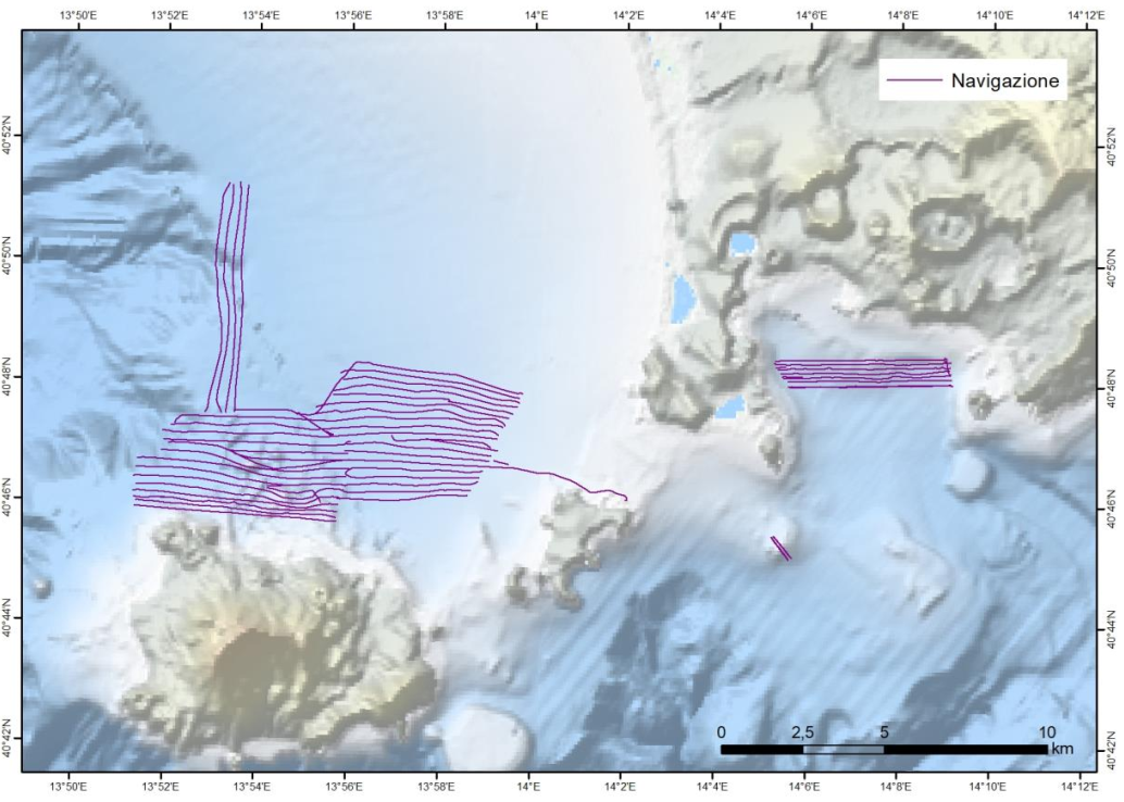
Survey FEAMP Procida
Nell’ambito del progetto FEAMP ISSPA (Linea 1.4 e Linea 2.51) è stato effettuato un rilievo Multi Beam allo scopo di indagare i fondali relativi alle aree identificate come potenzialmente idonee all’acquacultura. Tali rilievi hanno lo scopo di completare la mappa degli habitat bentonici e delle caratteristiche fisiche del substrato necessario alla corretta pianificazione spaziale marittima e all’identificazione delle pressioni multiple all’interno dell’area marina protetta Regno di Nettuno e del Sito Natura 2000 Fondali marini di Ischia Procida e Vivara. Il rilievo è stato effettuato con Multi Beam Knosgber 2040 C e Seapath 130-J. Sono state effettuate sonde per il profilo di velocità dell’acqua circa 2 volte al giorno con Mini SVP Valeport. È stata effettuata la calibrazione dello strumento all’inizio del rilievo e sono stati corretti i parametri di pitch, yaw a roll. L’elaborazione preliminare dei dati è stata effettuata a bordo con il software CARIS HIPS and SIPS ed è stato prodotto un DTM e un mosaico della riflettività a 1 m di risoluzione per tutta l’area indagata. Le mappe sono state estituite con il software ArcGIS 10.8.
Simple
- Date ( Creation )
- 2022-08-09
- Presentation form
- Digital document
- Credit
- © FEAMP ISSPA
- Status
- Completed
- Maintenance and update frequency
- As needed
- Survey type Survey type ( Theme )
-
- Cartography
- Habitat mapping
- Fisheries and aquaculture
- Device Device ( Theme )
-
- Multibeam
- Keywords
-
- oceanographic cruise
- FEAMP ISSPA
- Tyrrherian Sea
- Campania
- Procida
- GEMET - INSPIRE themes, version 1.0 GEMET - INSPIRE themes, version 1.0 ( Theme )
-
- Elevation
- Habitats and biotopes
- Continents, countries, sea regions of the world. Continents, countries, sea regions of the world. ( Place )
-
- Mediterranean Region
- Italy
- Tyrrhenian Sea
- Use limitation
- none
- Access constraints
- Other restrictions
- Other constraints
- FEAMP ISSPA data policy
Resource constraints
No information provided.
- Use constraints
- Other restrictions
- Other constraints
- FEAMP ISSPA data policy
- Classification
- Unclassified
- Metadata language
- en
- Topic category
-
- Geoscientific information
N
S
E
W
))
- Supplemental Information
- mediterranean sea; tyrrhenian sea; italy; campania region
- Distribution format
-
-
PDF
(
(.pdf)
)
-
PDF
(
(.pdf)
)
- OnLine resource
-
Cruise report
(
WWW:LINK-1.0-http--link
)
PDF
- OnLine resource
-
Cruise report
(
WWW:LINK-1.0-http--link
)
.pdf
- Hierarchy level
- Non geographic dataset
- Other
- Report
Conformance result
- Date ( Revision )
- 2021-04-20
- Explanation
- Validated in Geonetwork according to the ISO19115 rules (24/24)
- Pass
- Yes
- Statement
- Report produced by Dr. F. Foglini (ISMAR-CNR) in March 2010, as part of the oceanographic cruise ARCADIA_2010
- File identifier
- 3172bdf6-b980-4593-9568-a1235f00ae62 XML
- Metadata language
- en
- Character set
- UTF8
- Parent identifier
- dedbe528-16d8-4528-91a7-d572118813b3 dedbe528-16d8-4528-91a7-d572118813b3
- Hierarchy level
- Non geographic dataset
- Hierarchy level name
- Report
- Date stamp
- 2026-05-15T11:28:01
- Metadata standard name
- ISO 19115:2003/19139
- Metadata standard version
- 1.0
Overviews

Spatial extent
N
S
E
W
Provided by

Associated resources
Not available