 FEAMP GeoNetwork catalogue
Type of resources
Topics
INSPIRE themes
Keywords
Contact for the resource
Provided by
Years
Formats
Update frequencies
status
-

Acoustic biomass estimates (trend)
-

The geological map was produced by APAT, the Agency for the Protection of the Environment and for Technical Services, as a summary of the surveys carried out on a national scale as part of the CARG Project, National Geological Cartography, at a scale of 1: 50,000. Some changes were necessary for the volcanic themes of the Neapolitan area.
-

Map showing the position and the zoning of the protected site "Area Marina Protetta Parco Sommerso di Gaiola" in the Campania region
-
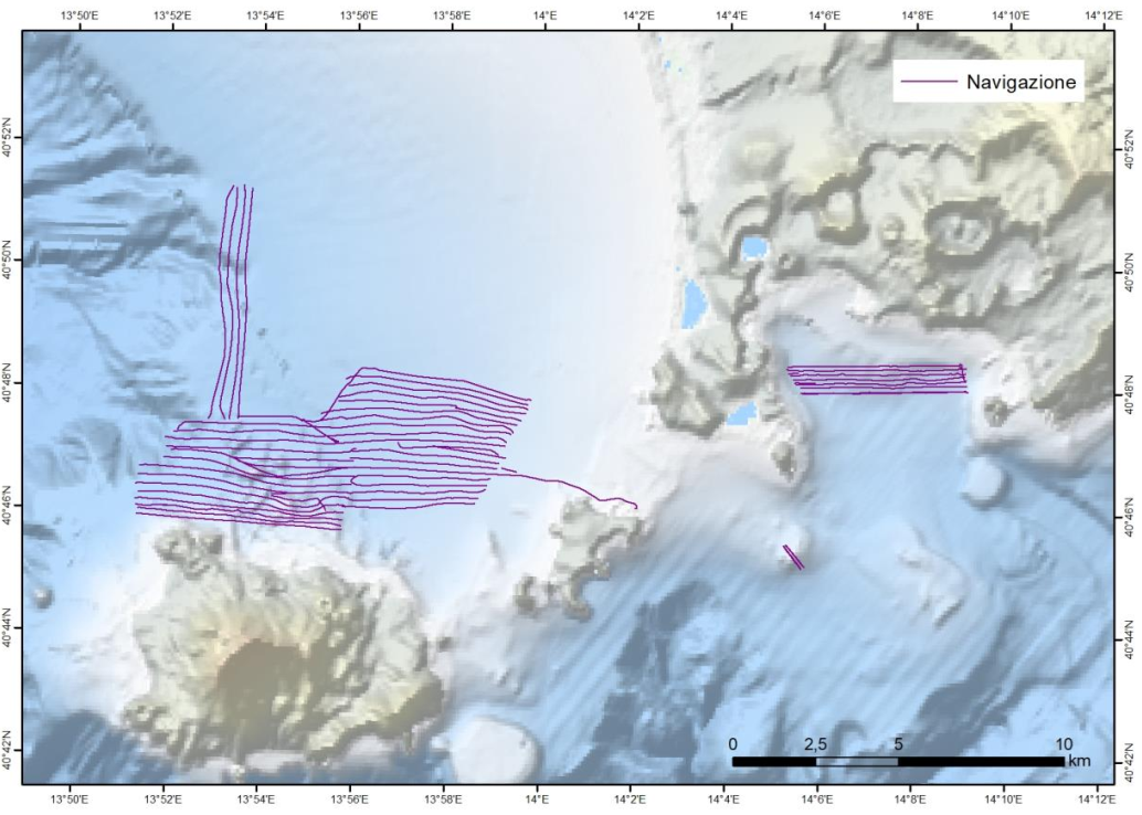
Nell’ambito del progetto FEAMP ISSPA (Linea 1.4 e Linea 2.51) è stato effettuato un rilievo Multi Beam allo scopo di indagare i fondali relativi alle aree identificate come potenzialmente idonee all’acquacultura. Tali rilievi hanno lo scopo di completare la mappa degli habitat bentonici e delle caratteristiche fisiche del substrato necessario alla corretta pianificazione spaziale marittima e all’identificazione delle pressioni multiple all’interno dell’area marina protetta Regno di Nettuno e del Sito Natura 2000 Fondali marini di Ischia Procida e Vivara. Il rilievo è stato effettuato con Multi Beam Knosgber 2040 C e Seapath 130-J. Sono state effettuate sonde per il profilo di velocità dell’acqua circa 2 volte al giorno con Mini SVP Valeport. È stata effettuata la calibrazione dello strumento all’inizio del rilievo e sono stati corretti i parametri di pitch, yaw a roll. L’elaborazione preliminare dei dati è stata effettuata a bordo con il software CARIS HIPS and SIPS ed è stato prodotto un DTM e un mosaico della riflettività a 1 m di risoluzione per tutta l’area indagata. Le mappe sono state estituite con il software ArcGIS 10.8.
-

Geologic map of Giffoni Valle Piana - Scale 1:25.000 - Sheet 467 NE
-

Map showing the position and the zoning of the protected site "Parco Archeologico Sommerso di Baia" in the Campania region
-

Geologic map of Salerno - Scale 1:25.000 - Sheet 467 SO
-

Map showing the location and the extent of the protected site " Parco Marino di Punta degli Infreschi" in the Campania Region designated as SAC and SPA with the Natura 2000 code "IT8050037"
-

Map showing the location and the extent of the protected site "Fasce litoranee a destra e sinistra del fiume Sele" in the Campania Region designated as SAC with the Natura 2000 code "IT8050010"
-

Map showing the location and the extent of the protected site "Fondali Marini di Ischia, Procida E Vivara" in the Campania Region designated as SCI with the Natura 2000 code "IT8030010"