 FEAMP GeoNetwork catalogue
geoscientificInformation
Type of resources
Available actions
Topics
INSPIRE themes
Keywords
Contact for the resource
Provided by
Years
Formats
Representation types
Update frequencies
status
-
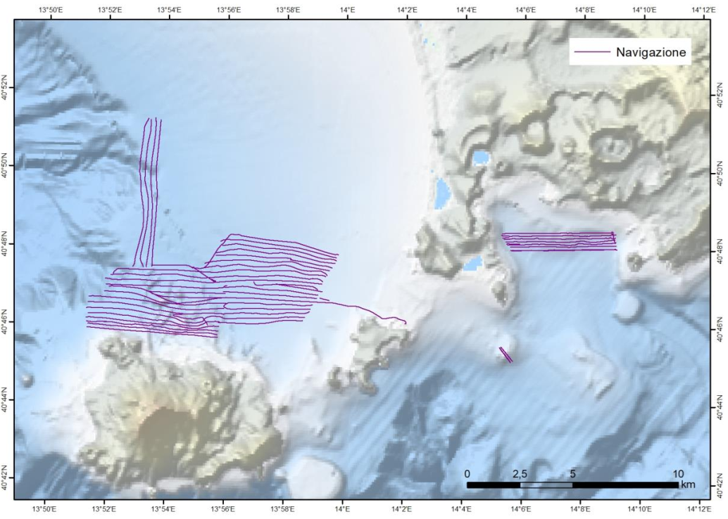
Nell’ambito del progetto FEAMP ISSPA (Linea 1.4 e Linea 2.51) è stato effettuato un rilievo Multi Beam allo scopo di indagare i fondali relativi alle aree identificate come potenzialmente idonee all’acquacultura. Tali rilievi hanno lo scopo di completare la mappa degli habitat bentonici e delle caratteristiche fisiche del substrato necessario alla corretta pianificazione spaziale marittima e all’identificazione delle pressioni multiple all’interno dell’area marina protetta Regno di Nettuno e del Sito Natura 2000 Fondali marini di Ischia Procida e Vivara. Il rilievo è stato effettuato con Multi Beam Knosgber 2040 C e Seapath 130-J. Sono state effettuate sonde per il profilo di velocità dell’acqua circa 2 volte al giorno con Mini SVP Valeport. È stata effettuata la calibrazione dello strumento all’inizio del rilievo e sono stati corretti i parametri di pitch, yaw a roll. L’elaborazione preliminare dei dati è stata effettuata a bordo con il software CARIS HIPS and SIPS ed è stato prodotto un DTM e un mosaico della riflettività a 1 m di risoluzione per tutta l’area indagata. Le mappe sono state estituite con il software ArcGIS 10.8.
-

Shaded relief image (not georeferenced) from multibeam data acquired in the Gulf of Pozzuoli in Campania Region
-

The shapefile contains the marine substrates of the Campania Region (inside 24 NM) produced in the framework of the FEAMP-ISSPA Project by CNR-ISMAR starting from the CARG cartography and the EUSeaMap from EMONnet.
-

The shapefile contains the priority habitats of the Campania Region (inside 24 NM) produced in the framework of the FEAMP-ISSPA Project by CNR-ISMAR. It is the results of a bibliographic review coupled with new data (FEAMP-ISSPA) and recovered geophysics data collected by CNR-ISMAR through the years. The shapefile includes coralligenous, maerl, Posidonia oceanica, Cymodocea nodosa, photophilic algae, bioconstructions, and cold-water corals.
-

Complete coastline features for Campania Region with a description of the typology and status
-

The map of geosites identifies the places where important evidence of the history of the geological evolution of the Campania Region is preserved, and being elements of landscape, scientific and cultural value, they will be suitably inserted in a landscape planning context as points or nodes of the ecological network, which representative aspects of regional geodiversity.
-

Geosites digitized from "Carta dei Geositi della Campania"
-

This cartography provides a first overview on a scale of 1: 250,000, of the thermal and mineral heritage of Campania inserted in the geological and hydrogeological context of the area. The data reported on the map derive from a collection of hydrogeological, geochemical and geo-structural information from regional archives, scientific works and specific studies carried out in the context of geological sheets (CARG Project).
-

Geosites digitized from "Carta delle acque minerali e termali della Regione Campania"
-

Benthic habitat map of the Campania Region produced in the framework of the FEAMP-ISSPA Project by CNR-ISMAR